
Cape Peron: Exmouth, Carnarvon, Monkey Mia
April 18, 2005
The mind-numbing drive to the coast was endless and flat. I do mean flat. Three other travelers I met have confirmed this notion: "The landscape is so flat, the sky so bright, the horizon so distant and so black, that you reckon you can see the curvature of the earth."
Finally, Exmouth (pop 2500) on the North West Cape.
Exmouth rhymes not with Plymouth, Falmouth or Weymouth, but with "Pak Wan." That's what the Thai girls call me when I try to say something nice to them. "Pak Wan" means Sweet Mouth. Exmouth.
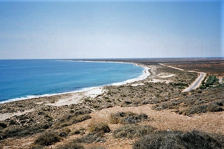
Put your left hand on the table, palm up. Fold back all your fingers except your index finger. That's the North West Cape. 100 kms long, poking up into the intense colors of the Indian Ocean. Here and all along the Coral Coast, the water near the shore is a creamy, buttery light green. In the distance the sea is a serious blue black.
My drive around the cape included stops at the wreck of the SS Mildura, Vlamigh Head Lighthouse, T-Bone Bay and then a beach break at the exquisite Turquoise Bay where I truly needed my Coppertone SPF 45 Sunblock Lotion with Parsol 1789 for extra UVA protection.
Later, a trek along the rim of the gorge above Tardie Creek where the sea has scratched out a steep, deep, long, narrow inlet. I can imagine a distant future when the sea will claw its way east across the finger/cape to Exmouth Gulf and the cape will be an island.
Heading south I stopped for coffee at the aptly named Coral Bay (pop 120) and ended the 375 km drive at Carnarvon. (OK. OK. Here's the calculation: multiply kms by .62 to get miles. 375km x .62 = 232 mi. As I drive I just multiply by .60 to estimate the distance.)
Carnarvon (pop 6900) sits on the mouth of the Gascoyne River. Like the Murchison, it flows from east to west, beginning its 700km journey in the Carnarvon Range.
(If you surf to Google.com before I do, how is it that a town on the west coast has the same name as a mountain range 700 kms to the east?)
Years ago, Carnarvon was a port for shipping sheep. So, how to get the sheep on to large ocean going ships? Why, build a jetty, of course. The jetty here is one mile long. So after a long walk on a good path alongside the rail tracks, from the edge of town across the mud flats and mangrove of Whitlock Island and Babbage Island, I arrived at the sea and the jetty.
I hopped on the little train, the "engineer" gave a loud "toot-toot" and we rode one mile out to sea on the narrow wooden jetty.
Normally, the Indian Ocean is quite pacific (!!!). Not today. Windy. I had mixed feelings. I knew that this little train makes dozens of trips out here every day. Yet, here I was one mile off shore, anxiously snapping photos, just above the roiling sea of black and white. One mile off shore. One mile . . . off shore. Out to sea.
Now for all his long, young life, your friend Jan has had a peculiar habit. Whenever the crowd says, "Oh, you've got to see that place" or, "Oh, everybody loves that music" I usually cross it off my list. Disneyland? Disney World? Never been there. So when everyone here said "Monkey Mia" I put an "X" in my guidebook.
"Monkey Mia, (pronounced my-ah . . . already I was suspicious) has become world-famous for the bottle-nose dolphins that turn up in the shallows like clockwork every day. It's so popular that the morning feeding session can become a bit of a circus - makes you wonder if the dolphins come to see the human show."
OK.OK. So I decided to go for the morning feed. A couple of young, informative Rangers with microphones and buckets of fish. Lots of kids in the water with the dolphins. It was nice. I liked it. Next stop, EPCOT? "Hey, you never know." Just don't hold your breath.
OK. Put your left hand on the table again, palm up. Fold back your thumb, index finger and pinkie. Dick Hartog and Cape Peran are like your middle finger and forefinger poking up into Shark Bay and the Ocean. The road leading to Dick Hartog Island is called "Useless Loop." I resisted the temptation to see it.
Monkey Mia is on Cape Peron. But my favorite spots were Hamelin Pool, Shell Beach and Eagle Bluff.
Hamelin Pool is a marine reserve containing the world's best known colony of stromatolites - modest microbes almost identical to organisms that existed 1 billion 900 million years ago (some say 5 billion) and evolved into more complex life. Living for millions of years in earth's original oxygen-poor environment, these microbes produced enough oxygen to provide the foundation of life.
Let's think about it the next time we are posing or primping or prancing or perambulating, postulating, pontificating, praying, prognosticating or just plain puckering up: Our vehicle may have begun life in Mt Whaleback iron-ore mine, but you and I owe our lives to a squat brown rock-like formation bubbling in the salty sea.
Bright, white Shell Beach and Eagle Bluff are . . . what they are. Tiny white cockleshells cement together making sturdy white bricks used for buildings in Denham. Eagle Bluff overlooking the sea - use your imagination.