
Juifen, Fusing, Hualin: "Molded Rocks and Waterfalls"
Hualien
Taiwan
November 1, 2007
Dear Family and Friends,
The first test of my dormant driving skills begins in Taipei. Did I say "skills?" I am so intimidated by the city traffic that I insist the car rental agency chauffeur me to the edge of town, and deposit me at the entrance to the Expressway, National Highway 1. Alone now, I ease on to the truck-filled route. I hug the right lane and chug north towards the port city of Keelung.
Let's give credit where credit is due: the road signs in Taiwan are frequent and in English, with accurate route numbers and unambiguous directional arrows.
I exit National Highway 1 to Provincial Road 62, and follow the signs through the clogged narrow streets of Keelung. Then out of town on Rte. 62 to District Road 102 to Juifen, a town in the northeast hills. Yes, I can still read a map.
The Northeast Coast Scenic Area and the Yeliou Scenic Area are just that: "scenic." The view from my room to the misty craggy coast on the East China Sea . . . . Scenic. The steep green hills and hillside temples around Juifen….Scenic. The Yeliou coastline with "delightfully odd rock formations formed by eons of wind and sea erosion…." * Scenic. "Hundreds of pitted and molded rocks with quaint (but accurate) names like Queen's Head and Fairy's Shoe"* . . . . Really, scenic.
The drive through the forested hills from Juifen to the coastal Route 2 and then south on Route 9 through Yilan City to Cilan is a cruise in the park. But now the line on the map looks like it was scrawled by a hyperglycemic boy with a red pencil in his angry fist. Never mind. My destination is Fusing. Let's take a drive.
The road to Fusing is the languorous and verdant drive that a holiday adventure is all about: bright green hillsides, sheer gray mountain walls, silver suspension bridges and red steel-arch bridges that span deep gorges and white rapid rivers.
Fusing is a delightful mountain town with a dozen shops selling huge bales of mushrooms. I have never seen so many piles of mushrooms, of all sizes and colors.
Far, far below the terrace of my hotel lies a graceful, and tempting, steel suspension pedestrian bridge that seems to float just above the slim width of Shimen Reservoir. Down, down the shaded mountain path I go and, oh so tentatively, step out on to the narrow wooden-planked walkway. I tread gingerly and cross the water to an aboriginal agricultural village. The buildings are decorated with ancient geometric designs and the views across the farmland are splendid and encouraging. I am a bit more confident now as I march back across the bridge. But now I face the upward climb to the hotel.
One again, outside of Fusing, I am challenged by a long walk down to the Xiao Wulai Waterfall. Pouring down from the mountain peaks, the white cascade falls 40m and crashes into a rocky stream below the walkway. I can feel the breeze and the spray on my face. I am happy to retrace my steps up the convenient path.
I retrace my route to the east and follow Route 9 south to Hualien on the East Coast National Scenic Area. In a word: scenic. The Caves of the Eight Immortals is a prehistoric archaeological site. The caves are filled now with religious icons. The Platform of the Three Immortals is a series of arched bridges that span the shallow water and lead to a small island off shore. It's raining hard so with umbrella in one hand and camera in the other, I manage a few shots of the rocky shore but the bridge and the island will have to wait for me until next time.
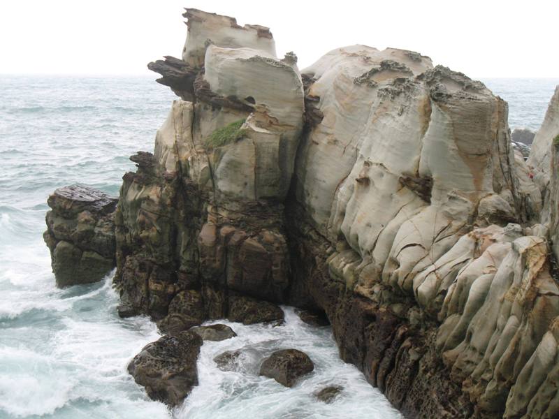
Geology draws me once again, this time to Hsiao Yeliu. "Known for its bizarre rock and coral formations, formed over thousands of years by wind and water erosion, the coastal landscape is truly unearthly here, with rocks curving and twisting into all manner of fantastic shapes."* TYB, the rain has stopped so I wander and climb and crawl around this dynamic display of "unearthly" earthly power.
North of Hualien is Taroko National Park and Taiwan's most famous scenic spot, Taroko Gorge. "The Liwu River cuts through the center of the gorge for 20km before emptying into the sea, forging many deep valleys, ravines and waterfalls in its course." *
The English-speaking guide at The National Park Headquarters explains that a recent earthquake has closed the hiking trails to hidden shrines, temples and hot springs. But the road ahead is unobstructed. Did I remember to ask him about the weather? Never mind. Let's take a drive.
I make frequent stops along the route to photograph formations named Heavenly Tengo Rock, The Head of the Indian Chief, Elephant Head Rock, Lion Head Rock, Greeting Gorge, Tzeilu Cliff, Ching Shui Cliff, and Nine Turns Gorge. Several waterfalls pour from huge holes in the face of the rock. The massive striated marble cliffs were uplifted and thrust aside by the pressure of colliding tectonic plates; the stripes in the rock are vertical.
The tour of the gorge ends as I drive up a mountain to The Formosa Hotel. This a grand place in a romantic setting. I wander around the gift shop and lobby. The staff is friendly and dressed in traditional colorful Atayal tribal costume. I promise I will return one day.
After all the excitement and wonder, an exhausting and painstaking test of my driving skills may lie ahead. From Taroko Gorge I continue west on to the most demanding mountain road this side of the Khyber Pass. A fog bank rolls in. A mist shrouds the mountains. A soup spills on to the roadway. Who knew? I refuse to turn back.
Will I survive this day and arrive safely at Sun Moon Lake?
Let's take a drive.
Pray for me,
Jan
* "Taiwan." Lonely Planet. 2004.